
Abby Wilson’s favourite hike in the Nelson area is the White Queen Trail near Whitewater.
“It’s an alpine hike close to town that’s easily accessible for a smaller car,” she says. “It has beautiful golden larches in the fall and a huge view on top.”
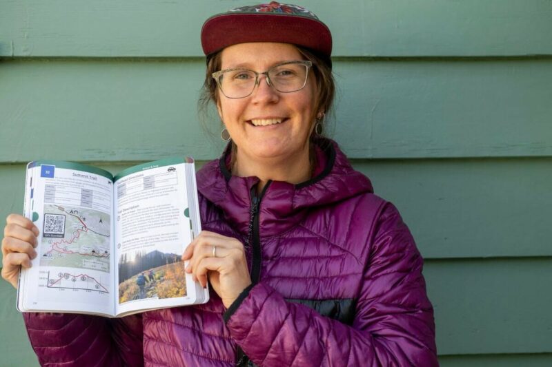
White Queen is one of eight local hikes and 77 regional hikes described in her new book West Kootenay Hiking, which will be launched on May 31 at 7 p.m. in a multimedia presentation at the Nelson Public Library; it’s on bookstands now.
Wilson’s website, also called West Kootenay Hiking, has over the last several years become a popular hub for outdoor information, with 50,000 views per month in the summer. Wilson spends a lot of time responding to questions about such things as access roads and trail conditions.
But hikers need a book, she says, because the hiking publications entitled Don’t Waste Your Time in the West Kootenay and Where Locals Hike in the West Kootenay (versions of the same book) are both out of print.
So the website, while it will continue as before, is also morphing into a book.
Two years ago Wilson left a corporate job to spend half her time on West Kootenay Hiking (maintaining the website as well as writing, designing and self-publishing the book), and the other half on her career as a visual artist. Wilson sells acrylic landscape paintings on her site Abby Wilson Art.
The two pursuits mesh together well.
She’ll go on a hike and document everything about the trail for West Kootenay Hiking. On the trail she photographs the landscape, then uses the photos to create the paintings she displays and sells on her art site.
“It’s a good lifestyle,” she says. “I feel really lucky to be able to do that. Being self-employed has ups and downs, but since becoming a mom, I really enjoy the flexibility that it gives me.”
The four pages about the White Queen Trail in the new book are packed with information about the trail’s difficulty level (moderate), total distance (10.2 kilometres), hiking season (July to September), duration (5 to 6 hours, out and back), elevation gain (691 metres), access vehicle (two-wheel-drive, low-clearance), and its features (big views, summit, golden larches, history, and yes, you can take your dog).
She also gives readers a detailed topographical map with driving instructions, photos taken on the trail, details trail heads (these can sometimes be hard to find) and the various stages of the hike.
You’ll also find places to go if you want to explore further, and a QR code that leads to GPS files delivered straight to your favourite navigation app.
Wilson’s book divides the West Kootenay into 10 areas with five to 10 hikes for each area. Nelson and Area hikes include Pulpit Rock and the Flagpole, Lyons Bluff, Toad Mountain, Sproule Creek, Smallwood Lookout, White Queen, Summit Trail and Ymir Peak.
Land of possibility
Wilson and her husband moved from Ontario to B.C. in 2016, searching for the perfect small town in the mountains.
“We moved here in early spring, just as the green was coming out, and it just felt like there’s so much possibility, and so much to explore. It just felt like this is the land of possibility.”
Wilson started the blog that became the hiking website, became active in the mountaineering club and got to know the various trail societies in the region.
She said she’s tried biking, trail running, downhill skiing, rock climbing, and likes them all.
“But hiking is just really freeing, to be out at a natural pace, in the wilderness, in the mountains. … For me, it’s that physical health piece, it’s the mental health piece, being in nature, and then it’s something you can do with friends and family. And so it can be very social, right?”
She now has a young child and less free time.
“And so going for a hike, I know I’m getting my exercise, I’m seeing friends, I’m out in nature, my mood is boosted for the weekend. It just covers a lot of ground for me.”
Wilson leads hikes on Sunday mornings for parents and tots.
Most challenging, easiest and most obscure
Wilson says the most challenging hike in the book is the Seven Summits Trail in the Rossland Range.
“It’s about 30 km end-to-end, so you’re in for a long day. It’s not so common to hike it, but folks do trail run it as well. You have to kind of arrange for a vehicle drop or something, since there’s two trail heads.”
Even harder is the Earl Gray Pass trail, a multi-day hike from Argenta to Invermere, which Wilson decided not to include in the book because it is a historic trail only partially restored and not maintained.
“There’s five cable car crossings. There’s ancient old growth forests. But it is just a gnarly adventure. You’re kind of trying to find the trail going through avalanche paths in the rain.”
The easiest hike in the book Wilson says, is Tulip Creek Falls near Castlegar, a half-kilometre round trip. She wanted to include short hikes for families with small children and people just getting into hiking.
Perhaps the least-known trail is the Telegraph Trail, she says, being built by the North Slocan Trail Society north of New Denver.
“It follows a historic telegraph line of the valley. It’s a beautiful mossy forest, and it has little fairy slipper orchids coming up later in May.”
Wilson points out that all the trails in the book are publicly funded trails on Crown land.
“These trails have all received funding. They’re official trails. They’re under Recreational Sites or Trails BC or BC Parks and the trail societies really do want folks to use them and enjoy them. They’re built for people to use.”
Plan your adventures throughout the West Coast at westcoasttraveller.com and follow us on Facebook and Instagram @thewestcoasttraveller. And for the top West Coast Travel stories of the week delivered right to your inbox, sign up for our weekly Armchair Traveller newsletter!


 BC Ferries adding over 1,000 round trips for busy summer season