Mobile Menu

  • Destinations
    • Canada
      • British Columbia
      • Alberta
      • Yukon
    • U.S.A.
      • Alaska
      • Washington
      • Oregon
      • California
    • Indigenous Tourism
    • West Coast Galleries
  • Things To Do
    • Staycation Secrets
      • Canada
        • Vancouver Island, B.C.
        • Okanagan
        • Lower Mainland, B.C.
        • Northern B.C.
        • Interior B.C.
        • Alberta
        • Yukon
      • U.S.A.
        • Alaska
        • Washington
        • Oregon
        • California
    • Adventure
      • Hiking
      • Camping
      • Beaches
      • Biking
      • Skiing
      • Fishing
      • Rafting
      • Adrenaline
    • Sip & Savour
    • Family Activities
  • Share Your Experience
    • Join Our Team
    • Contests
      • Okanagan Summer Getaway
      • Win Round Trip Flights
      • 10 Adventures Contest
      • Winter Road Trip With RVezy
      • Paddle Tour 2021
    • The Armchair Traveller Newsletter
  • Nature & Wildlife
    • Nature Photography
    • Wildlife Photography
  • About
    • Impressive West Coast
    • West Coast Partners
    • Contact Us
  • Search
  • Facebook
  • Flickr
  • Instagram
  • Twitter
  • YouTube
  • Menu
  • Skip to left header navigation
  • Skip to right header navigation
  • Skip to primary navigation
  • Skip to secondary navigation
  • Skip to main content
  • Skip to primary sidebar
  • Skip to footer

Before Header

  • Facebook
  • Flickr
  • Instagram
  • Twitter
  • YouTube

West Coast Traveller

  • Destinations
    • Canada
      • British Columbia
      • Alberta
      • Yukon
    • U.S.A.
      • Alaska
      • Washington
      • Oregon
      • California
    • Indigenous Tourism
    • West Coast Galleries
  • Things To Do
    • Staycation Secrets
      • Canada
        • Vancouver Island, B.C.
        • Okanagan
        • Lower Mainland, B.C.
        • Northern B.C.
        • Interior B.C.
        • Alberta
        • Yukon
      • U.S.A.
        • Alaska
        • Washington
        • Oregon
        • California
    • Adventure
      • Hiking
      • Camping
      • Beaches
      • Biking
      • Skiing
      • Fishing
      • Rafting
      • Adrenaline
    • Sip & Savour
    • Family Activities
  • Share Your Experience
    • Join Our Team
    • Contests
      • Okanagan Summer Getaway
      • Win Round Trip Flights
      • 10 Adventures Contest
      • Winter Road Trip With RVezy
      • Paddle Tour 2021
    • The Armchair Traveller Newsletter
  • Nature & Wildlife
    • Nature Photography
    • Wildlife Photography
  • About
    • Impressive West Coast
    • West Coast Partners
    • Contact Us
  • Search
You are here: Home / Travel / Tsilhqot’in place names adopted for five geographical features

Formerly Niut Mountain, ʔEniyud is located east of the north end of Telhiqox Biny and north of the Homathko Icefield. (Tsilhqot’in National Government)

Tsilhqot’in place names adopted for five geographical features

February 1, 2021 //  by Rebecca Dyok, Local Journalism Initiative Reporter

Share this:

Tsilhqot’in names have been officially adopted for several geographical features in B.C.’s Cariboo.

Five names were proposed by the Tsilhqot’in National Government and supported by the Cariboo Regional District, Rec Sites and Trails BC, Cariboo Mountain Bike Consortium, Avalanche Canada, BC Mountaineering Club and Association of Canada Mountain Guides.

While the names were officially adopted in June 2020, Carla Jack, provincial toponymist, a person who studies place names, noted events relating to COVID-19 delayed the implementation of the names and notifications from many communities.

The names follow a comment period from April 2019 to June 2020 in which seven governments and organizations provided comments to the BC Geographical Names Office.

A spokesperson with the Ministry of Forests, Lands, Natural Resources and Rural Development noted geographical names reflect heritage values that evolve over time and convey aspects of an area’s history.

“Indigenous place names are the original names, or names in the original languages, of the land,” says spokesperson Tyler Hooper. “Recognizing and documenting Indigenous place names is vital to preserving Indigenous knowledge systems and living traditions, increasing the visibility of Indigenous cultures in British Columbia, and increasing understanding of the deep history of the province.

“This is in keeping with Article 13 of the United Nations Declaration on the Rights of Indigenous Peoples.”

Of the 28 place names officially adopted in the Cariboo-Chilcotin region in the last five years, 23 were Tsilhqot’in.

Recently adopted names are:

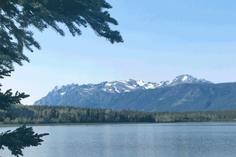
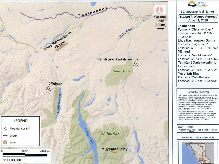
ʔEniyud (pronounced Enni-yoot), formerly Niut Mountain, for the mountain located just east of the north end of Telhiqox Biny, north of the Homathko Icefield. According to Tsilhqot’in legend, ʔEniyud was once a human woman married to a man named Tŝ’ilʔoŝ. When conflict drove them to separate, they and their children were turned to stone and became mountains. Today, both ʔEniyud and Tŝ’ilʔoŝ are considered powerful agents that protect and oversee their respective areas. Tsilhqot’in teach that these powerful mountains like ʔEniyud and Tŝ’ilʔoŝ should be shown great respect.

Lhuy Nachasgwen Gunlin (pronounced Lhoo-ee Nachas-gwen Goo-leen), formerly Eagle Lake located just south of Tatla Lake and north of Cochin Lake. Lhuy Nachasgwen Gunlin is the Tsilhqot’in name meaning “where there are many small fish” which refers to this lake as well as the wider area.

Tsalhanqox (pronounced Tsah-lhan-koh), formerly Chilanko River, adopted for the river that flows east into Little Chilcotin River east of Tsideldel. Tsalhanqox is the Tsilhqot’in name meaning “river with many beavers” from the Tsilhqot’in words “Tsa” (beaver), “Lhan” (many) and “yeqox” (creek/river).

Tsintŝanŝ Xadalgwenlh (pronounced Tseen-tsoss Hadal-gwelh) for a mountain located just northwest of Scum Lake west of the Taseko River. It is a Tsilhqot’in name meaning “mountain at Tsintsans”. The name Tsintsans refers to a wider locality which includes Tsintŝanŝ Biny (Scum Lake). Xadalgwenlh means “hill or small mountain.”

Yuyehtah Biny (pronounced Yu-yeh-tah Bee), formerly Yohetta Lake, adopted for the lake located west of Taseko Lakes, east of Tsilhgox Biny and south of Nemiah Valley. “Yuyetah Biny” is a Tsilhqot’in name meaning “lake at Yuyetah” where “Yuyetah” is a proper noun referring to that area/ valley and “biny” means “lake.”

Share this:

Category: TravelTag: British Columbia Destinations, Canada, Cariboo, Indigenous, Indigenous Tourism, Travel

Related Posts

You may be interested in these posts from the same category.

Pigeon Lake draws community curlers to outdoor rink

Despite a pandemic keeping community members physically distanced, Pigeon Lake neighbours have been creative this…

Pigeon Lake draws community curlers to outdoor rinkRead More

Mystery Mountain Hop: Documentary recounts quest for largest peak on the B.C. coast

It’s the largest peak on the B.C. coast and the namesake of Vancouver Island’s most…

Mystery Mountain Hop: Documentary recounts quest for largest peak on the B.C. coastRead More

Island wildlife viewers thrilled by close view of passing Orca pod

It was a wildlife photographer’s bonanza on Feb. 27 when a pod of orca passed…

Island wildlife viewers thrilled by close view of passing Orca podRead More

Cow moose rescued from frozen pond east of Williams Lake

Williams Lake residents and a conservation officer rescued a cow moose after it fell through…

Cow moose rescued from frozen pond east of Williams LakeRead More

All aboard! Train traces the epic Klondike journey

What do the Eiffel Tower, the Panama Canal and the Statue of Liberty all have…

All aboard! Train traces the epic Klondike journeyRead More

Year-long logging halt aims to bolster northern spotted owl habitat near Hope

The last known wild northern spotted owls in Canada have been given a new shot…

Year-long logging halt aims to bolster northern spotted owl habitat near HopeRead More

Summer is sweet at Sugar Lake (and winter’s pretty cool, too!)

Emerging from winter, you may be dreaming of a vacation with sunny skies, warm water…

Summer is sweet at Sugar Lake (and winter’s pretty cool, too!)Read More

VIDEO: New Mt. Cain ski documentary eye-candy for powder lovers

A freeskiing documentary set at Vancouver Island’s Mount Cain is making waves online. Frozen in…

VIDEO: New Mt. Cain ski documentary eye-candy for powder loversRead More

BC provincial camp reservations start March 8

If you’re planning for summer nights under the stars in British Columbia’s provincial parks, camping…

BC provincial camp reservations start March 8Read More

Previous Post: « Cyclists across BC commit to a winter ride Feb. 12
Next Post: Vernon filmmaker gives inside look at Winter Carnival’s ice park »

Primary Sidebar

Things To Do

Pigeon Lake draws community curlers to outdoor rink

March 2, 2021

Mystery Mountain Hop: Documentary recounts quest for largest peak on the B.C. coast

March 2, 2021

Island wildlife viewers thrilled by close view of passing Orca pod

March 2, 2021

Cow moose rescued from frozen pond east of Williams Lake

March 2, 2021

Recent Posts

Pigeon Lake draws community curlers to outdoor rink

March 2, 2021

Mystery Mountain Hop: Documentary recounts quest for largest peak on the B.C. coast

March 2, 2021

Island wildlife viewers thrilled by close view of passing Orca pod

March 2, 2021

Cow moose rescued from frozen pond east of Williams Lake

March 2, 2021

Footer

The West Coast Traveller has an immense social media footprint, with eight social media sites and 100,000+ Facebook followers.

Join us on social media and Join Our Community by sharing your stuff!

Get Inspired

News Media Groups

Black Press Media
Sound Publishing
Oahu Media Group
Alaska
Boulevard Magazines
Used.ca

Let’s Get Social

West Coast Traveller
I Love British Columbia
I love Alberta
I Love Yukon
I Love Washington
I Love California
I Love Oregon
I Love Alaska

Site Footer

  • Facebook
  • Flickr
  • Instagram
  • Twitter
  • YouTube

Copyright © 2021 West Coast Traveller and · All Rights Reserved